
India Geography Mixed Quiz 5: Himalayan Ranges, Passes, Rivers, Dams, Lakes and Channels (Clerkship 2024)
A little practice. A step forward.
20 questions on the geography of India for WBPSC Clerkship 2024.
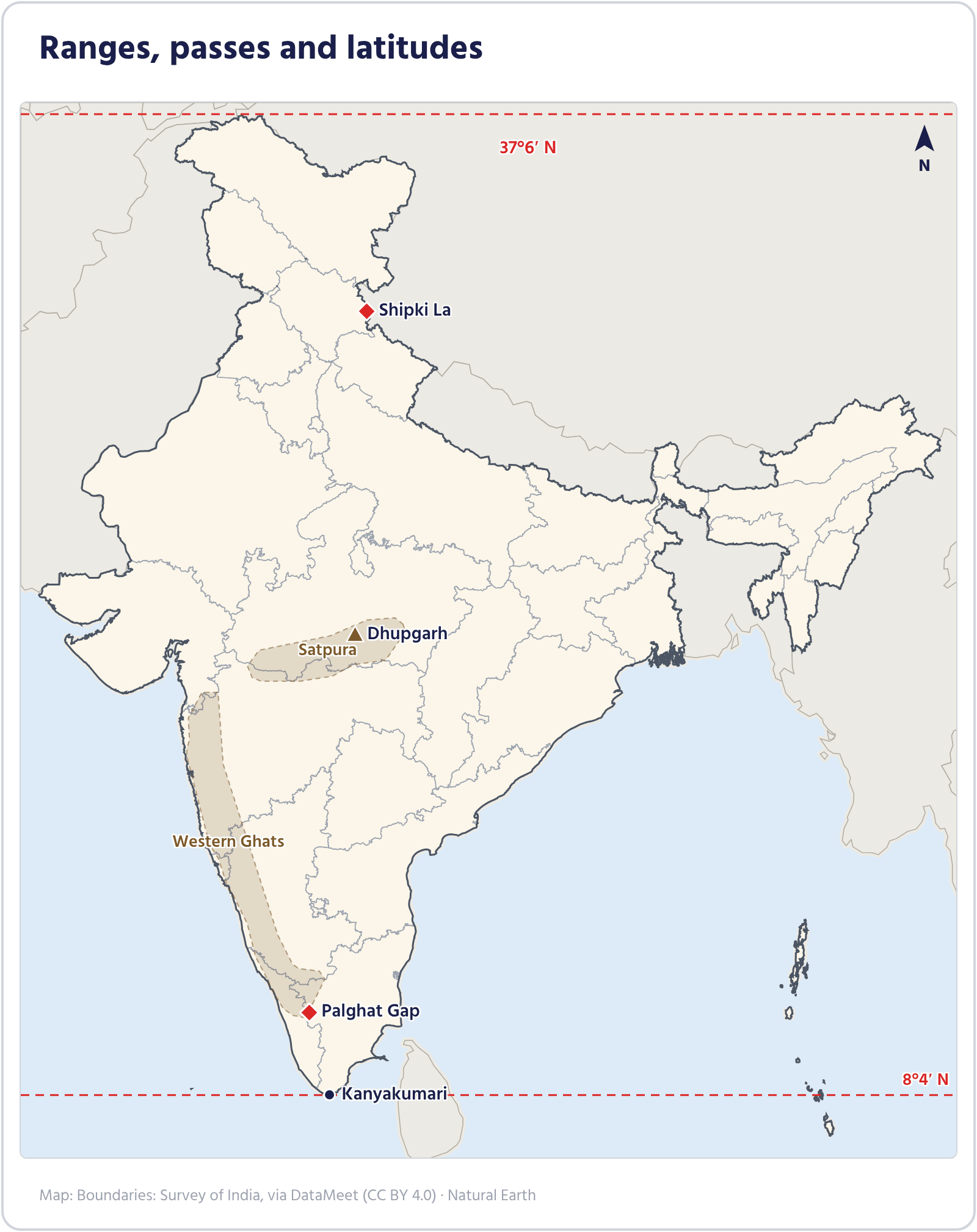
Between which latitudes does India's mainland extend?
India's mainland extends from 8°4′ N to 37°6′ N, so the whole country lies in the northern hemisphere. 6°45′ N is the latitude of Indira Point in the Andaman and Nicobar Islands, not of the mainland. 68°7′ E to 97°25′ E is the longitudinal extent, and 23°30′ N is the Tropic of Cancer, which divides the country into almost two halves.
- Latitude: 8°4′ N – 37°6′ N (mainland)
- Longitude: 68°7′ E – 97°25′ E
- The Tropic of Cancer (23°30′ N) passes through the middle of the country
- 6°45′ N (Indira Point) is the southern limit of the whole country, not of the mainland
- Latitude "8 to 37", longitude "68 to 97": both span about 30°
What share of the world's total land area does India have?
India's area is about 3.28 million sq km, which is about 2.4% of the world's total land area. India is the seventh largest country by area. 3.28 is the area in million sq km, not a percentage: that is where students slip.
- Area: about 3.28 million sq km
- About 2.4% of the world's land area
- Seventh largest country by area
- 3.28 is the area (million sq km), not a percentage
- "2.4% of the land, seventh place"
Which is the southernmost (outer) range of the Himalaya?
Of the three parallel ranges of the Himalaya, the Shiwalik is the southernmost and the lowest, so it is called the Outer Himalaya. The Himadri is the northernmost and highest range, the Himachal lies in between. The Karakoram belongs to the Trans-Himalaya, north of the Himalaya.
- The wide valleys between the Shiwalik and the Himachal are called duns (Dehradun)
- The Shiwalik is made of river-borne sediments and gravel
- Himadri is the highest, Shiwalik the lowest
- North to south: Himadri → Himachal → Shiwalik
| Range | Position | Height and features |
|---|---|---|
| Himadri (Great Himalaya) | Northernmost | About 6,000 m on average, the highest peaks |
| Himachal (Lesser Himalaya) | Middle | 3,700–4,500 m, hill stations (Shimla, Mussoorie, Darjeeling) |
| Shiwalik (Outer Himalaya) | Southernmost | 900–1,100 m, the duns |
The three parallel ranges of the Himalaya
What is the narrow pebble-strewn belt at the foot of the Shiwaliks, where streams disappear underground, called?
Coming down from the hills, the rivers deposit pebbles in a belt about 8–16 km wide at the foot of the Shiwaliks; this is the Bhabar, where water sinks through the porous gravel. South of it lies the Terai, where the streams re-emerge and form marshes. Bhangar and Khadar are the older and newer alluvium of the plains.
- Bhabar: pebbles, streams vanish
- Terai: streams re-emerge, marshy
- Bhangar is older alluvium, Khadar newer
- Streams vanish in the Bhabar and reappear in the Terai: swapping them is a common mistake
- Order coming down the hills: Bhabar → Terai → plains
| Belt | Where | Features |
|---|---|---|
| Bhabar | At the foot of the Shiwaliks, 8–16 km wide | Pebbles and gravel, streams disappear underground |
| Terai | South of the Bhabar | Streams re-emerge, marshes and thick forest |
| Bhangar | Higher parts of the plain | Older alluvium, kankar (lime nodules) |
| Khadar | River floodplains | Newer alluvium renewed by floods each year, fertile |
Divisions of the northern plains
Dhupgarh is the highest peak of which range?
Dhupgarh (about 1,350 m), near Pachmarhi in Madhya Pradesh, is the highest peak of the Satpura Range. The Satpura runs east–west between the Narmada and the Tapi. The Aravalli's highest peak is Guru Shikhar, and the Vindhya lies north of the Narmada.
- Dhupgarh: Pachmarhi, Madhya Pradesh
- Satpura: between the Narmada (north) and the Tapi (south)
- Highest in the Aravalli: Guru Shikhar
- Pachmarhi sits on the Satpura
Shipki La, the pass through which the Sutlej enters India from Tibet, is in which state?
Shipki La is in Kinnaur district of Himachal Pradesh, on the India–Tibet (China) border; the Sutlej enters India through it. Uttarakhand's passes include Lipulekh and Mana, Sikkim's Nathu La and Jelep La, and Arunachal's Bomdi La.
- Shipki La: Kinnaur, Himachal Pradesh
- The Sutlej enters India through it
- Sikkim: Nathu La; Uttarakhand: Lipulekh
- Sutlej → Shipki → Himachal
| Pass | State / region |
|---|---|
| Zoji La | Ladakh |
| Shipki La | Himachal Pradesh |
| Lipulekh | Uttarakhand |
| Nathu La | Sikkim |
| Bomdi La | Arunachal Pradesh |
Some Himalayan passes
The Palghat Gap connects which two states?
The Palghat (Palakkad) Gap is the low break in the Western Ghats between the Nilgiri and Anaimalai hills; roads and railways between Kerala and Tamil Nadu run through it. Monsoon winds also pass east through this gap. Two other well-known passes of the Western Ghats, Thal Ghat and Bhor Ghat, are in Maharashtra.
- Between the Nilgiris (north) and the Anaimalai (south)
- Links Palakkad in Kerala with Coimbatore in Tamil Nadu
- Thal Ghat, Bhor Ghat: Maharashtra
- Palghat = Palakkad (Kerala) to Coimbatore (Tamil Nadu)
The Dhuandhar Falls at Bhedaghat near Jabalpur are on which river?
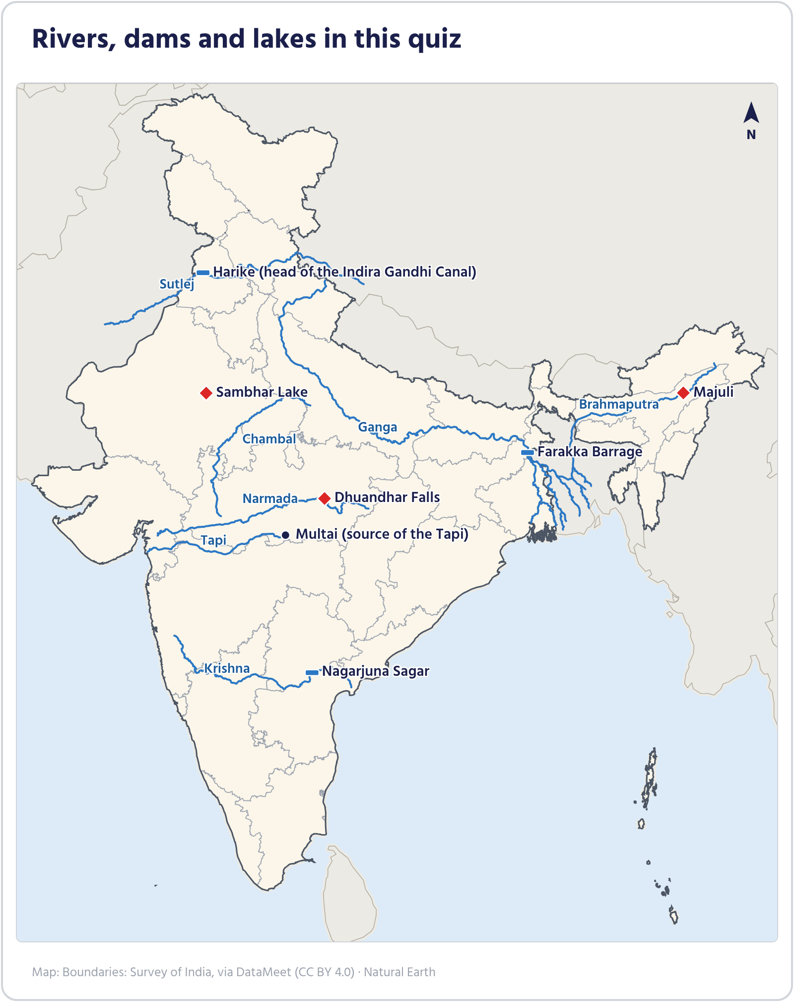
The Dhuandhar Falls are at Bhedaghat near Jabalpur in Madhya Pradesh, on the Narmada, which flows here through a gorge of marble rocks. The name comes from the smoke-like spray the falling water throws up. The Tapi and the Son also rise in Madhya Pradesh, but these falls are not on them.
- Bhedaghat, Jabalpur, Madhya Pradesh
- A gorge of marble rocks
- The Narmada flows west into the Arabian Sea
- Dhuan (smoke) + dhar (stream), on the Narmada's Marble Rocks
Which tributary of the Indus rises near Rakas Tal in Tibet?
The Sutlej rises at Rakas Tal near Mansarovar in Tibet and enters India through Shipki La. The other tributaries of the Indus rise in India: the Beas near the Rohtang Pass, the Jhelum at Verinag in Kashmir, and the Chenab where the Chandra and Bhaga meet in Himachal. The Bhakra-Nangal dam is on the Sutlej.
- Sutlej: from Rakas Tal (Tibet)
- Beas: near the Rohtang Pass
- Jhelum: Verinag, Kashmir
- The five tributaries west to east: Jhelum, Chenab, Ravi, Beas, Sutlej
| Tributary | Source |
|---|---|
| Jhelum | Verinag, Kashmir |
| Chenab | Meeting of the Chandra and Bhaga, Himachal |
| Ravi | Kullu hills, Himachal |
| Beas | Near the Rohtang Pass, Himachal |
| Sutlej | Rakas Tal, Tibet |
The five tributaries of the Indus
Which river valley is best known for its ravines (badlands)?
The Chambal has cut deep gullies and ravines into soft alluvium, the badlands spread over Madhya Pradesh, Rajasthan and Uttar Pradesh. The Chambal is a tributary of the Yamuna and rises on the Malwa plateau of Madhya Pradesh. The Gandak and Kosi are Himalayan tributaries of the Ganga, and the Betwa is another tributary of the Yamuna.
- Chambal: a tributary of the Yamuna
- Rises on the Malwa plateau
- The Gandhi Sagar and Rana Pratap Sagar dams are on it
- "Chambal ravines" go together
Where does the Tapi rise?
The Tapi rises in the Satpura hills near Multai in Betul district of Madhya Pradesh and flows west into the Gulf of Khambhat near Surat. Amarkantak is the source of the Narmada, Trimbakeshwar of the Godavari and Mahabaleshwar of the Krishna. Like the Narmada, the Tapi flows through a rift valley and forms an estuary, not a delta.
- Tapi: Multai, Betul (Madhya Pradesh)
- Flows west into the Gulf of Khambhat
- Surat stands on the Tapi
- Source pairs: Narmada–Amarkantak, Tapi–Multai, Godavari–Trimbak, Krishna–Mahabaleshwar
| River | Source | Falls into |
|---|---|---|
| Narmada | Amarkantak | Arabian Sea (Gulf of Khambhat) |
| Tapi | Multai | Arabian Sea (Gulf of Khambhat) |
| Godavari | Trimbakeshwar, Nashik | Bay of Bengal |
| Krishna | Mahabaleshwar | Bay of Bengal |
Sources of four peninsular rivers
Majuli, India's largest river island, is in which river?
Majuli is a river island formed in the Brahmaputra in Assam, the largest in India. The Brahmaputra deposits huge loads of silt in the Assam valley and builds many sandbars and islands, of which Majuli is the biggest. The island is also known for its Vaishnava satras.
- Majuli: Brahmaputra, Assam
- India's largest river island
- A centre of Vaishnava satras
- Majuli sits mid-Brahmaputra
Sambhar, India's largest inland salt lake, is in which state?
Sambhar Lake is in Rajasthan, near Jaipur; it is India's largest inland (away from the sea) salt lake, and salt is made from its water. The Rann of Kutch in Gujarat is a salt marsh, not a lake, and Chilika is a brackish coastal lagoon in Odisha.
- Sambhar: Rajasthan, near Jaipur
- Largest inland salt lake, salt production
- Chilika: a brackish coastal lagoon (Odisha)
- Inland salt lake = Sambhar (Rajasthan); coastal brackish lagoon = Chilika (Odisha)
- Sambhar salt, Rajasthan desert
On which river is the Farakka Barrage in Murshidabad district built?
The Farakka Barrage stands across the Ganga in Murshidabad district of West Bengal. Its feeder canal sends Ganga water into the Bhagirathi-Hooghly, flushing silt to keep Kolkata port navigable. So the Bhagirathi gets water from the project, but the barrage itself is on the Ganga.
- Farakka: Ganga, Murshidabad
- The feeder canal supplies the Bhagirathi-Hooghly
- Aim: keep Kolkata port navigable
- The barrage is on the Ganga; the Bhagirathi only receives its feeder canal
| Dam / barrage | River | State |
|---|---|---|
| Farakka | Ganga | West Bengal |
| Nagarjuna Sagar | Krishna | Telangana–Andhra Pradesh |
| Bhakra | Sutlej | Himachal Pradesh |
| Hirakud | Mahanadi | Odisha |
| Sardar Sarovar | Narmada | Gujarat |
Some dams and their rivers
On which river is the Nagarjuna Sagar Dam?
The Nagarjuna Sagar Dam is on the Krishna, on the border of Telangana and Andhra Pradesh; it is one of the country's largest masonry dams. The Tungabhadra is a tributary of the Krishna with its own Tungabhadra Dam in Karnataka. The Godavari and Kaveri are separate rivers.
- Nagarjuna Sagar: the Krishna
- Telangana–Andhra Pradesh border
- Tungabhadra: a tributary of the Krishna
- Nagarjuna on the Krishna
| Dam / barrage | River | State |
|---|---|---|
| Farakka | Ganga | West Bengal |
| Nagarjuna Sagar | Krishna | Telangana–Andhra Pradesh |
| Bhakra | Sutlej | Himachal Pradesh |
| Hirakud | Mahanadi | Odisha |
| Sardar Sarovar | Narmada | Gujarat |
Some dams and their rivers
The Indira Gandhi Canal mainly waters the desert areas of which state?
The Indira Gandhi Canal starts at the Harike Barrage in Punjab (where the Sutlej and Beas meet) and brings irrigation and drinking water to the Thar desert of Rajasthan. It is one of India's longest canals. The canal starts in Punjab, but it is Rajasthan that mainly benefits.
- Head: Harike Barrage, Punjab
- Water: the Sutlej and Beas
- Benefits: the desert of western Rajasthan
- The canal starts in Punjab, but its water goes mainly to Rajasthan
What causes the light winter rain in north-west India, including Punjab and Haryana, which helps the rabi wheat crop?
In winter, cyclonic systems from the Mediterranean region, the western disturbances, bring light rain to north-west India and snow to the hills; this rain is very good for the rabi wheat. The north-east monsoon brings winter rain to the Tamil Nadu coast. The loo is the hot dry summer wind, and the nor'westers are summer storms.
- Western disturbances: cyclones from the Mediterranean
- Winter rain in north-west India, snow in the Himalaya
- Good for rabi crops (wheat)
- Winter rain: western disturbances in the north-west, the north-east monsoon in the south-east (Tamil Nadu)
| Wind / storm | Season | Where |
|---|---|---|
| Western disturbances | Winter | North-west India |
| Loo | Summer | Northern plains |
| Nor'westers (Kalbaishakhi) | Summer (Baisakh) | West Bengal, Assam |
| Mango showers | Late summer | Kerala, Karnataka coast |
Local winds and rain by season
Which state's coast gets most of its yearly rain from the retreating (north-east) monsoon in October–December?
During the south-west monsoon the Coromandel coast of Tamil Nadu lies in the rain shadow of the Western Ghats and gets little rain. In October–December the retreating monsoon picks up moisture over the Bay of Bengal and gives this coast most of its yearly rain. Kerala, Gujarat and West Bengal get most of their rain in June–September.
- Coromandel coast: winter rain
- Cause: the retreating monsoon carries moisture from the Bay of Bengal
- In the main monsoon this coast is in the rain shadow
- Chennai's rainy season is winter
What mainly gives red soil its red colour?
Red soil forms where ancient igneous and metamorphic rocks weather under low rainfall; iron from the rocks spreads through the soil as oxide and colours it red. When hydrated, the same soil looks yellow. Red soil is usually poor in organic matter, nitrogen and phosphorus.
- Red colour: iron oxide
- Looks yellow when hydrated
- Eastern and southern Deccan, Odisha, Chota Nagpur
- Rusty iron is red: red soil has the same iron oxide
| Soil | Reason for colour / name | Where |
|---|---|---|
| Red soil | Iron oxide | Eastern and southern Deccan, Chota Nagpur |
| Black soil (regur) | From basalt (lava) rock, compounds of titanium and iron | Deccan lava plateau |
| Laterite | Heavy rain leaches it, leaving iron and aluminium | Western Ghats, Odisha, Meghalaya |
Three soils compared
Which channel separates Minicoy island of Lakshadweep from the Maldives?
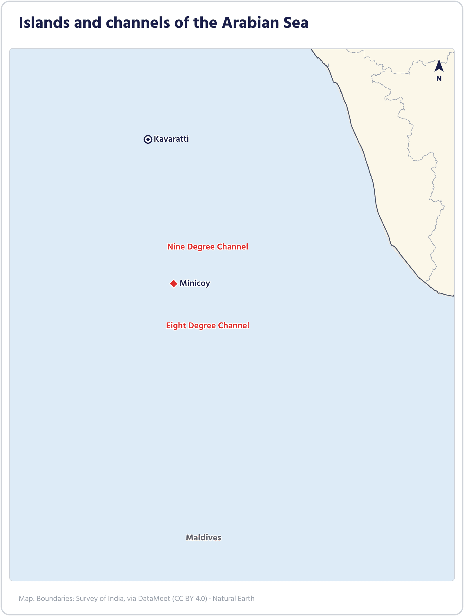
South of Minicoy, the Eight Degree Channel separates it from the Maldives; to its north, the Nine Degree Channel separates it from the rest of Lakshadweep. The Ten Degree Channel is in the Bay of Bengal, between the Andaman and Nicobar Islands. The Palk Strait lies between India and Sri Lanka.
- Eight Degree: Minicoy – Maldives
- Nine Degree: Minicoy – the rest of Lakshadweep
- Ten Degree: Andaman – Nicobar (Bay of Bengal)
- Both the Nine and Eight Degree Channels lie beside Minicoy: 9° to the north, 8° to the south
- The smaller the number, the further south: 8° toward the Maldives, 9° toward Lakshadweep
| Channel | What it separates |
|---|---|
| Eight Degree Channel | Minicoy (India) – Maldives |
| Nine Degree Channel | Minicoy – the rest of Lakshadweep (Kavaratti) |
| Ten Degree Channel | Andaman – Nicobar |
| Palk Strait | India – Sri Lanka |
Channels and straits
📊 Topic Analysis
20 questions on the geography of India for WBPSC Clerkship 2024.


Leave a Comment
Commenting as ·