
India’s Location, Area and Neighbours Quiz: Clerkship 2024
A little practice. A step forward.
10 questions on India’s location, area, standard time and neighbouring countries, each with an explanation. 📖 Read the detailed topic
Which imaginary line passes through roughly the middle of India?
The Tropic of Cancer (23°30′ N) runs through roughly the middle of India and divides it into a tropical and a subtropical part. The Equator (0°) and the Tropic of Capricorn (23°30′ S) do not cross Indian land. The Arctic Circle lies far to the north.
- Tropic of Cancer = 23°30′ N
- Crosses 8 states
- Southern India lies in the tropical zone
- India has the Tropic of Cancer, not Capricorn
- Cancer = north; Capricorn = south
| State | Tropic of Cancer |
|---|---|
| Gujarat | Crosses |
| Rajasthan | Crosses |
| Madhya Pradesh | Crosses |
| Chhattisgarh | Crosses |
| Jharkhand | Crosses |
| West Bengal | Crosses |
| Tripura | Crosses |
| Mizoram | Crosses |
Through which of these states does the Tropic of Cancer NOT pass?
The Tropic of Cancer passes through eight states: Gujarat, Rajasthan, Madhya Pradesh, Chhattisgarh, Jharkhand, West Bengal, Tripura and Mizoram. Odisha is not among them; the line goes from Jharkhand straight into West Bengal. The other three options are on the list.
- 8 states in all
- West to east: Gujarat to Mizoram
- Odisha and Bihar are not on the line
- Learn the order Gujarat-Rajasthan-MP-Chhattisgarh-Jharkhand-WB-Tripura-Mizoram
Near which city does the standard meridian of India (the basis of IST) pass?
India's standard meridian is 82°30′ E and it passes near Mirzapur in Uttar Pradesh. Its time is used for the whole country as IST, which is 5 hours 30 minutes ahead of GMT. Kolkata, Nagpur and Ahmedabad are not on this line.
- Standard meridian = 82°30′ E
- IST = GMT + 5:30
- 15° of longitude = 1 hour
- Kolkata is about 88°30′ E, east of the standard meridian
- 82½ ÷ 15 = 5½ hours
What is the approximate total area of India?
India's total area is 32,87,263 sq km, i.e. about 32.9 lakh sq km. This is roughly 2.4% of the world's land area. The other options are far below India's real area.
- Area = 32,87,263 sq km
- About 2.4% of world land
- North-south about 3,214 km; east-west about 2,933 km
- The north-south extent is greater than the east-west extent
- 32.87 lakh, 7th in rank
What is India's rank in the world by area?
India is the 7th largest country in the world by area. It is preceded by Russia, Canada, China, the USA, Brazil and Australia. Rank by population is a different matter and must not be mixed up with rank by area.
- 7th by area
- Ahead of India: Russia, Canada, China, USA, Brazil, Australia
- Rank by area differs from rank by population
- Six countries are bigger, so India is 7th
Largest states by area
How many countries does India share a land border with?
India has land borders with 7 countries: Pakistan, Afghanistan, China, Nepal, Bhutan, Bangladesh and Myanmar. Sri Lanka and the Maldives are neighbours across the sea and share no land border. So the figure is 7, not 9.
- 7 land neighbours
- Sea neighbours: Sri Lanka and Maldives
- Total land border about 15,100 km
- Sri Lanka and the Maldives have no land border with India
- Remember the seven by initials: Pa-Af-Ch-Ne-Bh-Ba-My
| Neighbour | Indian states bordering it |
|---|---|
| Bangladesh | West Bengal, Assam, Meghalaya, Tripura, Mizoram |
| Nepal | Uttarakhand, Uttar Pradesh, Bihar, West Bengal, Sikkim |
| Bhutan | Sikkim, West Bengal, Assam, Arunachal Pradesh |
| Myanmar | Arunachal Pradesh, Nagaland, Manipur, Mizoram |
With which country does India share its longest land border?
India's longest land border is with Bangladesh, about 4,096 km. West Bengal, Assam, Meghalaya, Tripura and Mizoram form part of it. The borders with China, Pakistan and Myanmar are shorter.
- Longest land border: Bangladesh
- 5 Indian states on it
- West Bengal borders Bangladesh, Nepal and Bhutan
- A bigger country (China) does not mean the longest border
- Bangladesh is almost wrapped around by India on three sides
What is the southernmost point of India, including the islands?
The southernmost point of India is Indira Point on Great Nicobar Island (about 6°45′ N). Kanyakumari is the southernmost point of the mainland (about 8°4′ N). Rameswaram and Port Blair lie farther north.
- With islands: Indira Point
- Mainland: Kanyakumari
- Indira Point was earlier called Pygmalion Point
- Check whether the question says 'mainland'
- Islands included = Indira; mainland = Kanyakumari
Which strait separates India from Sri Lanka?
The narrow waterway between India and Sri Lanka is the Palk Strait, linked with the Gulf of Mannar. The Malacca Strait lies between Indonesia and Malaysia. Bab-el-Mandeb is at the mouth of the Red Sea and Hormuz at the mouth of the Persian Gulf.
- India-Sri Lanka: Palk Strait
- Andaman and Nicobar are separated by the Ten Degree Channel
- Arabian Sea in the west, Bay of Bengal in the east, Indian Ocean in the south
- The Malacca Strait is not an Indian strait
- Palk = the India-Lanka passage
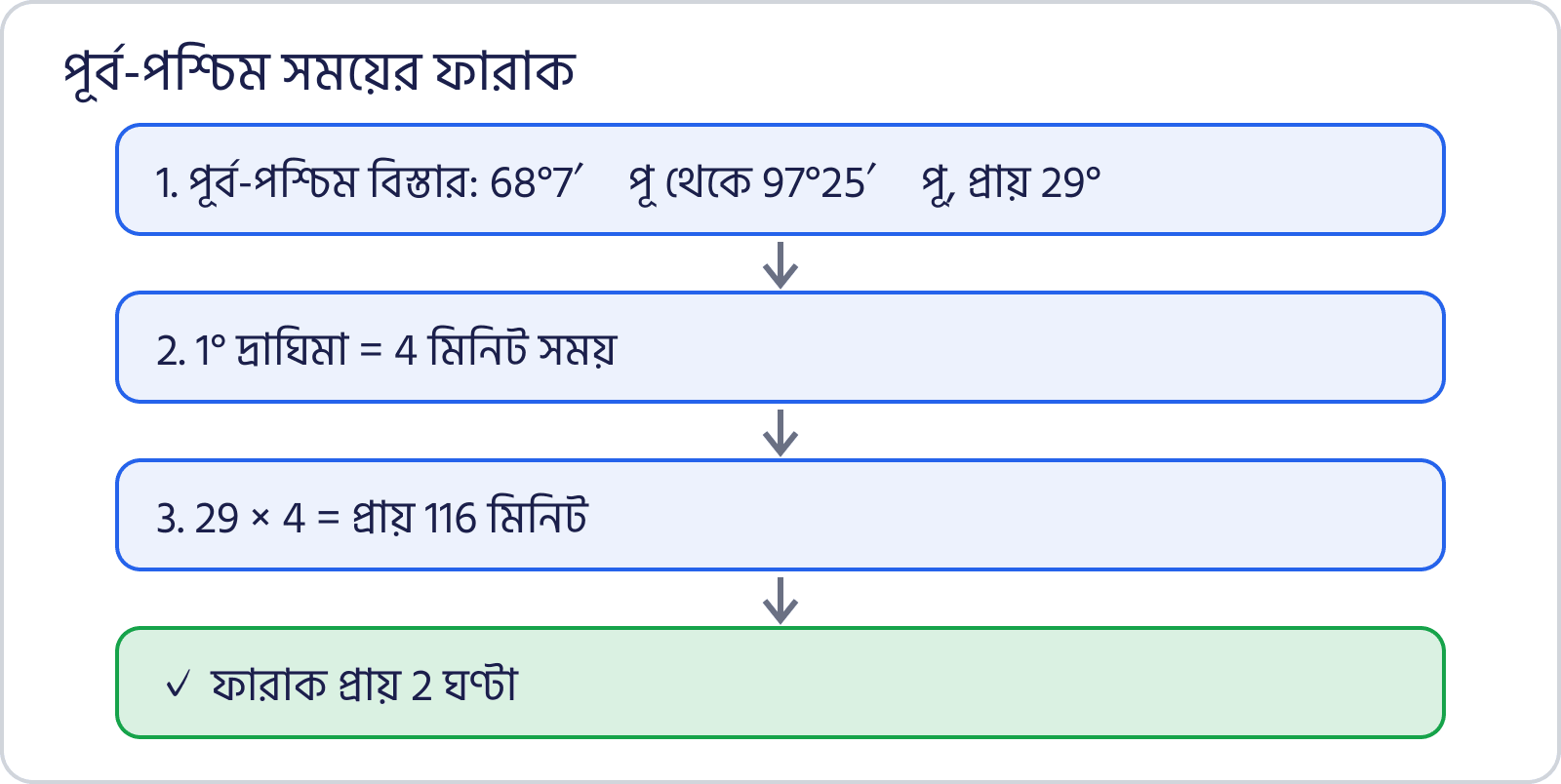
Roughly how much earlier does the sun rise in Arunachal Pradesh than in Gujarat?
India's east-west extent is about 29° of longitude. Each degree makes a 4-minute difference, so 29 × 4 is about 116 minutes, i.e. roughly 2 hours. So the sun rises about 2 hours earlier in eastern Arunachal than in western Gujarat.
- East-west extent about 29° (68°7′ E to 97°25′ E)
- 1° = 4 minutes; 15° = 1 hour
- One IST is used for the whole country
- The gap is about 2 hours, not 30 minutes
- 29 ÷ 15 is about 2, so about 2 hours
📊 Topic Analysis
10 questions on India’s location, area, standard time and neighbouring countries, each with an explanation.


Leave a Comment
Commenting as ·